China Seizure of Sandy Cay: A Deep Dive into South China Sea Tensions
China took control of a reef that both China and the Philippines claim and planted its national flag near a Philippine military base
sandeep gawdiya
4/27/20255 min read
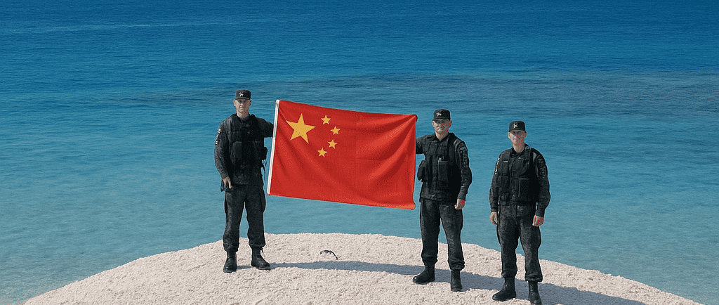
In mid-April 2025, China’s Coast Guard staged a highly symbolic operation on Sandy Cay, a tiny, uninhabited sandbank in the contested Spratly Islands. Only three kilometers from Thitu Island (known as Pag-asa in the Philippines), where Manila maintains a military airstrip and houses some 250 residents, Sandy Cay became the latest flashpoint in a long-running territorial dispute. Chinese media released images of officers planting the national flag, inspecting the reef, and clearing debris—actions Beijing described as “exercising sovereign jurisdiction.” This blog post examines the events leading up to the reef occupation, the legal arguments each side invokes, regional and international reactions, and what this means for future stability in one of the world’s most strategically vital waterways.
Historical Context: The “Nine-Dash Line” and Island-Building Campaigns
China’s modern drive to assert control over the South China Sea intensified between 2013 and 2016, when Beijing undertook massive land reclamation projects on several low-tide reefs, transforming them into fortified outposts. Features like Fiery Cross, Mischief, and Subi Reef—once submerged at high tide—were built up to host airstrips, hangars, deep-water ports, and missile batteries. By creating these installations under its self-declared “nine-dash line,” which stakes claim to roughly 90% of the sea’s expanse, China sought to underwrite its maritime sovereignty over a region through which trillions of dollars in global trade pass annually.
Although China has largely paused large-scale reclamation in recent years, the April flag-planting on Sandy Cay underscores that Beijing maintains both the capacity and the will to reinforce its claims through selective occupations and legal assertions.
The Sandy Cay Operation: Sequence of Events
According to state-run reports, Chinese Coast Guard vessels approached Sandy Cay in mid-April. Officers went ashore to:
Raise the Chinese Flag
The principal act of occupation—hoisting the national banner—sent a clear signal of China’s intent to treat Sandy Cay as its sovereign territory.Inspect for “Illegal Activity”
Personnel conducted on-reef inspections and video-recorded any perceived incursions by Philippine forces, framing their presence as necessary to deter unauthorised landings or resource collection.Clean Up Debris
Photographs show officers collecting plastic bottles, wooden sticks, and other refuse. While presented as an environmental service, this action underscored China’s claimed administrative control.
No permanent structures were erected, and there is no indication of an enduring garrison. Nevertheless, the symbolic exhibition of control marks a significant escalation in China’s maritime posture.
Legal Framework: Natural Features vs. Artificial Islands
Under the United Nations Convention on the Law of the Sea (UNCLOS), naturally formed islands that can sustain human habitation or economic life enjoy the right to a 12-nautical-mile territorial sea and a 200-nautical-mile exclusive economic zone (EEZ). In contrast, low-tide elevations—features submerged at high tide—do not generate such maritime entitlements.
China’s Position
Beijing asserts that Sandy Cay is a naturally occurring feature of sufficient size and permanence to merit a full territorial sea. Control of this reef would extend China’s claimed maritime boundary and overlap Manila’s EEZ around Thitu Island.Philippines’ Position
Manila rejects Sandy Cay’s qualification as an island under UNCLOS, arguing it cannot sustain habitation or economic life. The Philippines views China’s occupation as a direct challenge to its sovereign rights and to the ruling issued by an international tribunal in 2016, which invalidated China’s broad “nine-dash line” claims.
This clash of legal interpretations exemplifies “lawfare”—the strategic use of legal instruments and arguments to advance geopolitical objectives. By physically occupying Sandy Cay, China seeks to strengthen its legal case and pre-empt challenges to its wider maritime claims.
January Confrontation and Ongoing Patrols
Tensions over Sandy Cay first flared in January, when China claimed to have intercepted and “repelled” Philippine naval vessels that attempted to land and collect sand samples. Manila contends its missions were routine scientific surveys, while Beijing cast them as unlawful intrusions. In response, the Philippines has deployed its own coast guard cutters to monitor Sandy Cay and gather evidence of any Chinese reclamation or construction activity.
Regional and International Reactions
The Philippines has vocally condemned China’s actions as an escalation of maritime aggression. President Ferdinand Marcos Jr. has ordered intensified diplomatic engagement, including appeals to ASEAN partners and preparations for legal recourse at UNCLOS-designated forums.
Vietnam, Malaysia, Brunei, and Taiwan—all of which hold overlapping claims in the Spratlys—have expressed concern, viewing China’s occupation as a precedent that could weaken their own positions. ASEAN has issued calls for peaceful resolution based on international law, though consensus among member states remains fragile.
The United States weighed in through National Security Council spokesperson James Hewitt, who warned that China’s reef seizure “threatens regional stability and violates international law.” The U.S. reaffirmed its commitment to a “free and open Indo-Pacific” and signaled close consultations with allies to deter further unilateral actions.
Balikatan Exercises and Enhanced Defense Cooperation
Coinciding with the Sandy Cay operation were the annual Balikatan (“shoulder-to-shoulder”) exercises between Philippine and U.S. forces, held from April 21 to May 9. This year’s drills, involving some 17,000 troops, featured a landmark integrated coastal defense scenario:
MADIS (Medium Altitude Air Defense Integrated System)
A U.S. short-range air defense platform tasked with intercepting simulated drone threats.SPYDER (Surface-to-Air PYthon and DERby)
A Philippine medium-range system designed to counter simulated cruise-missile attacks.
Commander Matthew Sladek of the U.S. 3rd Littoral Anti-Air Battalion highlighted the complementary nature of the systems: “MADIS handles short-range targets. SPYDER is for medium-range threats. The more we train together, the stronger and more effective we become.”
These exercises illustrate Manila’s pivot toward deeper security ties with Washington, aimed at deterring further Chinese encroachment.
Expanded Enforcement Powers and Maritime Control
In June 2024, China’s coast guard regulations were broadened to allow officers to board foreign vessels in claimed waters and detain crew members for up to 60 days on suspicion of trespassing. This builds on the 2021 Coast Guard Law, which authorises use of force against ships deemed to have entered Chinese-claimed waters without permission. Coupled with occupations like Sandy Cay, these legal instruments provide a robust enforcement framework to underpin China’s maritime sovereignty claims.
Strategic Implications and Future Scenarios
Although Sandy Cay itself is tiny—approximately 200 square meters in area—its control carries outsized significance:
Strengthening Subi Reef Claims
By extending a 12-nautical-mile territorial sea from Sandy Cay, China could shore up its hold on nearby Subi Reef, a major artificial base with runways, hangars, and missile sites that, under international law, would not qualify as an island.Limiting Philippine Operations
A claimed maritime zone around Sandy Cay would constrain Manila’s patrols between the reef and Thitu Island, complicating routine resupply and surveillance missions.Signaling Resolve
The operation demonstrates Beijing’s willingness to assert control over even the smallest features, underscoring that its territorial ambitions extend beyond initial reclamation projects.
Most analysts believe China is unlikely to embark on new large-scale reclamation in the near term—its existing bases already provide extensive reach. Instead, similar low-key occupations and legal assertions may become the preferred method of further entrenchment.
Manila’s Options: Balancing Deterrence and Diplomacy
For the Philippines, countering China’s lawfare requires a multi-pronged approach:
Legal Action
Reinforcing its case at international legal forums to challenge China’s occupation of Sandy Cay and broader nine-dash line claims.Coast Guard Patrols
Maintaining a steady maritime presence around contested features, using non-lethal measures to assert rights without provoking armed conflict.Allied Cooperation
Deepening security partnerships, notably through expanded joint exercises and intelligence sharing with the United States and other like-minded nations.ASEAN Engagement
Working with regional neighbours to build consensus on code-of-conduct negotiations aimed at managing disputes peacefully.
Conclusion
China’s April occupation of Sandy Cay is a microcosm of the broader strategic contest unfolding in the South China Sea. Through a blend of physical presence, legal claims, and expanded enforcement powers, Beijing seeks to solidify its sweeping maritime assertions—actions that risk undermining the rules-based order enshrined in UNCLOS. For Manila and its allies, the challenge lies in upholding international law and freedom of navigation without triggering a military crisis.
As joint military exercises underscore the depth of Philippine-U.S. cooperation, diplomatic efforts within ASEAN and ongoing legal challenges will test whether multilateral mechanisms can effectively temper unilateral power plays. The fate of Sandy Cay may be small in scale, but its outcome will resonate in the geopolitics of a region central to global trade and security.
Updates
Delivering timely news and inspiring life stories.
Links
Contact
+917976343438
© 2025. All rights reserved.