Rare Hawaii Snowfall as Kona Low Brings Flooding Rain, High Winds and Winter Storm Conditions
A powerful Kona low is impacting Hawaii with flooding rain, thunderstorms, strong winds and rare snowfall on Maunakea. Learn why snow happens in Hawaii and what to expect next.
CLIMATE & ENVIRONMENT
Sandeep
1/6/20263 min read
Hawaii’s tropical image is being reshaped by an unusual burst of winter weather as a powerful Kona low brings heavy rain, strong winds, and rare snowfall to the islands, with Maunakea dropping below freezing and accumulating significant snow. While coastal and urban areas face flooding rain and thunderstorms, the state’s highest peak is experiencing full winter conditions, highlighting Hawaii’s dramatic elevation-driven climate contrasts and placing the islands under multiple weather warnings.
The severe weather is being driven by a Kona low, a cold, slow-moving low-pressure system positioned northwest of the islands that disrupts Hawaii’s normal trade winds and pulls deep tropical moisture across the state. According to the National Weather Service, this setup significantly increases the risk of prolonged heavy rainfall, thunderstorms, and rapid runoff, creating hazardous conditions that can lead to flash flooding, landslides, and swollen streams, particularly on windward and mountainous slopes.
As the Kona low strengthens, widespread impacts are being felt across the Hawaiian Islands, with persistent rainbands producing one to two inches of rainfall statewide and localized totals reaching much higher on the southern and eastern slopes of the Big Island and parts of Maui County. Emergency officials have warned that saturated soils and steep terrain increase the likelihood of urban flooding and landslides, while thunderstorms embedded within the rainbands may briefly intensify rainfall rates and worsen travel conditions across affected areas.
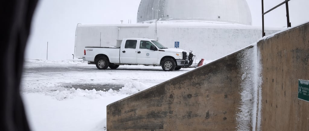
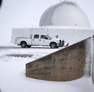
At higher elevations, the storm is producing true winter weather, with Maunakea and nearby summits experiencing freezing temperatures, accumulating snow, and dangerous ice. Winter storm warnings remain in effect as snowfall combines with strong winds to sharply reduce visibility, forcing summit road closures and making travel hazardous to impossible, while crews work to clear snow and manage icy conditions as the storm continues.
Although surprising to many, snowfall on Hawaii’s highest volcanoes is a recurring natural phenomenon, as peaks like Mauna Loa and Maunakea rise above 13,000 feet, where temperatures frequently fall below freezing during winter storms. When cold air associated with a Kona low combines with deep tropical moisture, precipitation that falls as rain at lower elevations can turn to sleet and snow at the summits, creating sharp weather contrasts within just a few miles.
Weather officials have issued flood, high wind, winter storm, and marine advisories across the state, urging residents and visitors to stay alert, avoid flooded roads, respect summit closures, and use caution on surrounding waters as hazardous seas and strong winds persist. Forecast models indicate the Kona low will gradually weaken, but lingering showers, gusty winds, and unstable conditions may continue into midweek, keeping the risk of flooding and summit snow in place before a slow return toward more typical island weather patterns.
This rare convergence of tropical rainfall and alpine snowfall underscores how dramatically Hawaii’s weather can shift during powerful winter systems, turning beach forecasts and mountain conditions into entirely different realities at the same time. As the Kona low slowly exits the region, officials continue to emphasize preparedness and awareness, reminding the public that Hawaii’s unique geography makes it especially vulnerable to rapid weather changes—from flooding at sea level to snow and ice high above the clouds.
Events like this Kona low highlight why Hawaii regularly appears in extreme weather searches despite its tropical reputation, as elevation, ocean influence, and winter storm patterns combine to produce rare but impactful conditions. From flooding rain and damaging winds to snow-covered volcanic summits, this system serves as a reminder that Hawaii’s weather risks extend far beyond hurricanes, making real-time forecasts, official warnings, and local advisories essential for residents, travelers, and outdoor enthusiasts alike.
As images of snow-dusted peaks and rain-soaked streets spread online, this Hawaii winter storm is drawing global attention and driving searches for “snow in Hawaii,” “Kona low explained,” and “Maunakea snowfall.” While the sight may seem extraordinary, meteorologists stress that such events are part of Hawaii’s complex climate system—one that blends tropical weather with high-altitude winter conditions, reminding audiences worldwide that even paradise can briefly turn into a winter landscape.
Hawaii Kona Low Weather Snapshot
Weather Element Details
Primary System Kona Low (cold, slow-moving low-pressure system)
Most Affected Areas Big Island, Maui County, windward and southeastern slopes
Rainfall 1–2 inches statewide; localized totals up to 8 inches
Flood Risk Flash flooding, urban flooding, landslides, rapid runoff
Thunderstorms Possible statewide as rainbands move through
Snowfall Locations Maunakea, Mauna Loa
Snow Accumulation 5–10 inches at summit elevations
Wind Speeds 50–60 mph at summits; gusts up to 75 mph possible
Visibility Near zero at times at higher elevations
Active Warnings Flood Watch, Winter Storm Warning, High Wind Warning
Marine Impacts Gale Warning, Small Craft Advisory, High Surf Advisory
Expected Trend Gradual weakening by midweek; lingering showers
Updates
Delivering timely news and inspiring life stories.
Links
Contact
+917976343438
© 2025. All rights reserved.